


ch Sadoux et montagne de Faraud

collot
User
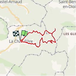

Length
13.2 km

Max alt
1185 m

Uphill gradient
665 m
Km-Effort
22 km

Min alt
724 m

Downhill gradient
666 m
Boucle
Yes
Creation date :
2019-01-15 16:17:06.568
Updated on :
2019-01-15 16:17:06.568
5h08
Difficulty : Medium

FREE GPS app for hiking
 SityTrail
IGN / Geographical institutes
SityTrail Plus
The world is yours!
About
Trail Walking of 13.2 km to be discovered at Auvergne-Rhône-Alpes, Drôme, La Chaudière. This trail is proposed by collot.
Description
La Chaudière à Saillans.
Positioning
Country:
France
Region :
Auvergne-Rhône-Alpes
Department/Province :
Drôme
Municipality :
La Chaudière
Location:
Unknown
Start:(Dec)
Start:(UTM)
675714 ; 4944585 (31T) N.
Comments